
Continents and Islands Maps (by Oleg Dolya) Level 2 Level 2
Module description
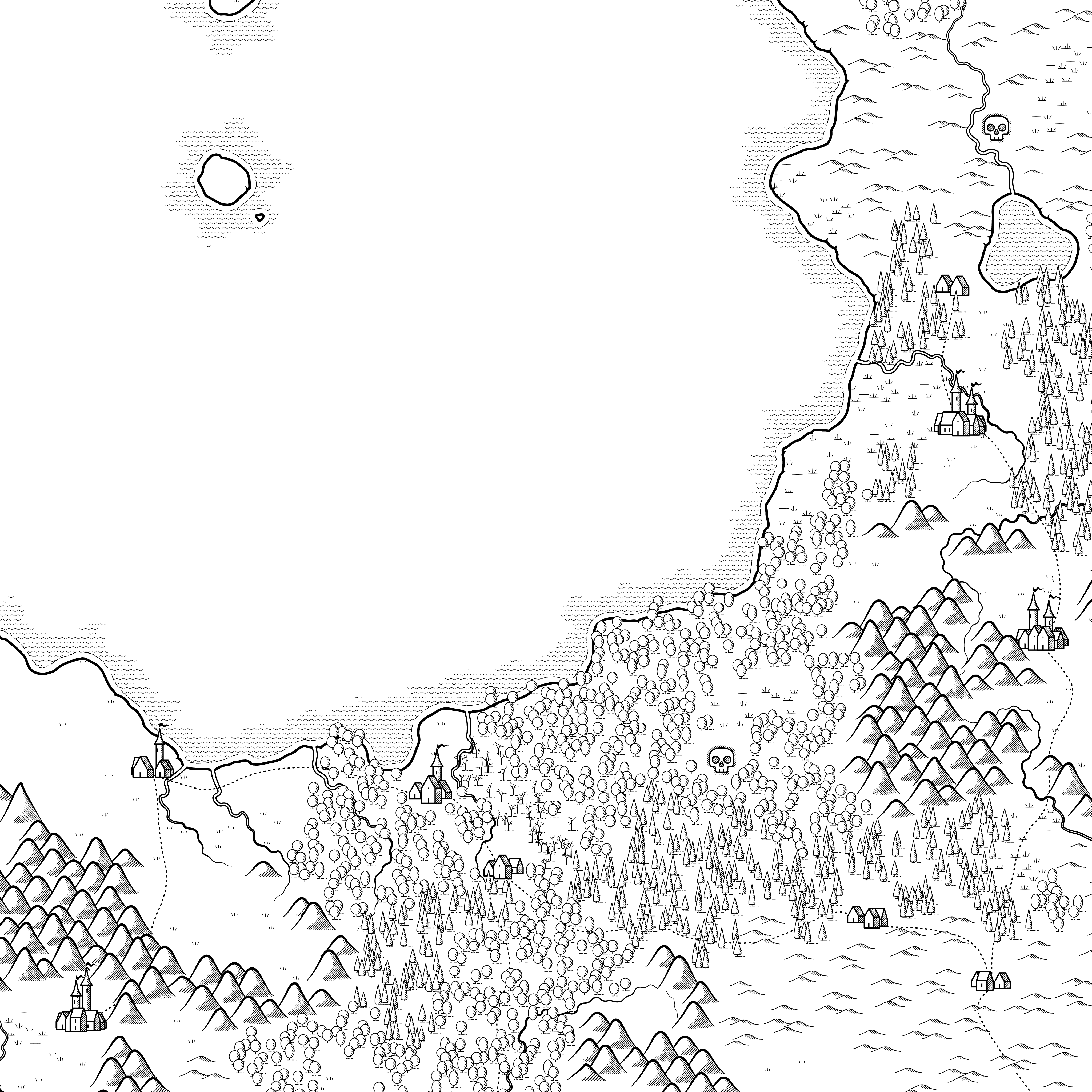
This is the Random Map Generator for Role Playing Games. In this module Game Masters will find sources of inspiration for their stories or a source of improvisation. Maps are a very important resource in RPG games. They help players to locate themselves, making them part of the world around them and allowing the game to develop with more consistency. It is also a powerful tool for Game Masters, as it allows a better organization, better cohesion of political intrigues, economy of the area, hot spots and dangerous areas.
Why have we chosen to expose only islands and continent coasts? In fantasy worlds it is not so important how big the area is but the story it is able to tell. A small territory with diversity, variety of urban centers, different habitats and above all stories to tell. An example of this is Tolkien's map of Middle Earth. It is just a coastline of a continent, but it holds within it thousands of stories that capture the attention and give an unparalleled richness. Remember that in the Middle Ages the areas were more unpopulated than today, so the plans shown could be many miles separating one area from another.
Natural habitats usually change every 10-100 miles, so a forest or plain can be approximately 10-20 miles in extent, and a mountain range 20-60 miles. In order to easily locate yourself you can calculate the distance between two towns on the map (or the players point to their objective) by counting how many different habitats there are and multiply by 10 to get how many miles separate one from the other. This is an easy and simple way to approximate a true estimate. (If you see that a forest, plain or mountain extends longer than the rest of the habitats count them as several habitats instead of as one).
The dungeons are marked as a skull. These dots do not mean that they are literally a structure with cells, prisons and narrow corridors. Dungeons in RPGs have a broader meaning and signify hostile places where there is a quest and an interesting story to tell. From wizards' towers to palaces of dark kings, pagan temples, pyramids of ancient gods, icy caves or dragons' lairs. These points that have the skull only means "Danger" and it is up to the Game Master to decide what type of adventure or threat it is. These dots may be affecting the surrounding towns and habitats.
For example, in J.R.R Tolkien's "The Lord of the Rings" there is a vast forest called the "Mirkwood". This is because "The Necromancer" inhabited a fortress in that area "Dol Guldur" and therefore dark beasts (bats, giant spiders and other beings) inhabited the area, attracted by evil. When the elves managed to expel the evil from the land, it was renamed "The Forest of Green Leaves", denoting that this hostile spot had already disappeared. This is a clear example of the importance of identifying on a map the habitats as well as the cities and places of conflict. The same can be seen in many other fantasy sagas such as Narnia, Harry Potter or very famous stories like "Beauty and the Beast".
These maps only provide information on three components: Civilizations (social component), Hazards (hot spots) and Habitats (environmental component). With these three components the rest of the parameters for a story can be formed. For example, cities give possibilities, stable habitats give resources and the absence of dangers gives prosperity. The separation between cities and metropolis determines politics, the number of dangerous spots determines poverty, and hostile and rough habitats hinder trade in the area. To learn more details about these parameters you can visit the modules on creating dungeons, civilizations, cities and habitats.
This tool is suitable for any role-playing system, be it Dungeons & Dragons, Pathfinder, GURPS, Aquelarre or any other medieval fantasy game. If you want to create names of cities, races, environments and enemies you will have to go to other modules of this website dedicated to it. These plans are provided by Oleg Dolya, a fantasy map maker and we thank him for his contribution to the web and the role-playing community.
How does this module work?
Simply click on "Generate"to display a complete map of the area. . The "Print" button will export the plan to an A4 document that can be printed or saved. You can select which type of map to display (Islands or Continents). Below is a brief legend with the symbology used in the maps:

Category
Tags
Advantages for Role Player
No advertising or ads
Create up to 500 modules
Create up to 500 tables
Creates tables with up to 300 lines
10.000 Role Points per month
Exclusive patron achievement
Acknowledgement in the credits
Project support for new functions

Level 1

Level 1

Level 1
Level 2

Level 1
Level 1